Wildlife conservation increasingly depends on timely information from large, remote, and difficult-to-access areas. Forests, wetlands, reservoirs, mountains, and protected zones can be challenging to inspect through ground patrols alone. Drones offer a flexible way to collect aerial imagery, but effective wildlife monitoring requires more than simply capturing photos. Conservation personnel also need fast mapping, reliable positioning, and efficient ways to identify and review objects in surveyed areas.
For conservation organizations and environmental management teams, the value of wildlife monitoring drones therefore depends on how efficiently aerial data can be converted into usable information. A system that combines aerial mapping, onboard recognition, and positioning can reduce the delay between data collection and operational decisions.
How Drone Object Detection Supports Wildlife Monitoring
Wildlife surveys often cover large areas where manual observation is time-consuming. A UAV can provide a broader view of terrain while reducing the need for personnel to enter difficult locations. However, the resulting imagery still needs to be reviewed to identify relevant objects or conditions.
Drone object detection can help organize this process by automatically identifying predefined target categories within aerial imagery. The approach can be useful for environmental inspection, where teams may need to locate people, vehicles, hazard points, or other detectable objects associated with conservation activities and site management.
The effectiveness of detection depends on the system’s recognition capabilities, positioning accuracy, image quality, and processing speed. For operational use, rapid access to results can be particularly valuable because teams may need to decide where to inspect next while the mission is still underway.
Why Real-Time Mapping Matters in Conservation Operations
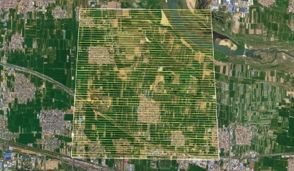
Mapping provides the spatial context needed to interpret aerial observations. Instead of viewing individual images separately, conservation teams can use an orthomosaic to understand where detected objects are located within the wider landscape.
This becomes especially useful in remote areas where conditions can change quickly. A real-time mapping workflow can provide updated terrain information during flight rather than requiring the team to wait for conventional post-flight processing.
Hunter Wing from Icecypress Technology is a man-portable UAV mapping and recognition system designed around this type of operational workflow. According to official product documentation, it delivers real-time orthomosaic mapping, airborne target recognition and high-precision positioning. This lightweight add-on unit connects directly to standard UAV remote controllers.
For conservation teams operating in mountains, reservoirs, or other difficult terrain, portability can be an important consideration. The additional computing module and power supply weigh under 600 g, while the system uses a three-step deployment process: power on, connect, and set the flight route.
Real-Time Object Tracking for Field Observation
Positioning is another important part of aerial conservation work. Identifying an object is less useful if operators cannot determine its location accurately enough for subsequent inspection or verification.
Hunter Wing supports real-time target coordinate capture and overlays position information with orthomosaic imagery. Its documented positioning accuracy is at the sub-meter level, allowing detected targets to be associated with spatial coordinates for inspection and verification. The system also streams imagery, recognition results, and location data to the ground station during operation.
This capability can support teams that need to review observations while a UAV is operating. Rather than waiting for all data to be processed after landing, operators can see recognition and positioning results during the mission. The product page specifies a recognition response time of no more than 0.5 seconds and describes automated aggregation of target quantity, type, and confidence information.
The distinction is important for buyers evaluating real-time object tracking. In this system, tracking is associated with mapping, recognition, and target positioning rather than specialized high-speed motion analysis. This makes it more relevant to spatial observation and on-site inspection workflows.
Portable UAV Technology for Environmental Inspection
Wildlife conservation can involve long patrol routes and areas that cannot be reached easily by vehicles. A portable UAV system can give small teams greater flexibility when operating in such environments.
Hunter Wing is specified for continuous operation of up to four hours when paired with its 24 V, 2000 mAh mobile power source. Its intelligent computing module consumes less than 25 W. These specifications are relevant when teams need to conduct extended patrols, surveys, or monitoring activities without carrying large amounts of additional equipment.
The product is also positioned for environmental inspections alongside emergency response, public safety, and security patrols. Its onboard processing approach allows mapping, recognition, and positioning to take place during flight, while mission results can later be uploaded to a cloud center or exported for downstream analysis, archiving, and reporting.
For conservation organizations, this creates a practical workflow: collect aerial information, identify relevant targets, associate observations with coordinates, and retain the resulting data for later review. It can complement rather than fully replace established ecological survey methods.
Choosing Wildlife Monitoring Drones for Field Operations
When evaluating wildlife monitoring drones, buyers should look beyond camera specifications. Key considerations include operating weight, deployment requirements, recognition speed, positioning accuracy, endurance, data transmission, and compatibility with existing UAV hardware.
The processing architecture also deserves attention. With onboard computation, teams can receive mapping and recognition results closer to the point of collection. This can reduce dependence on post-flight processing when immediate situational awareness is required.
For organizations considering drone object detection, the most useful approach is to define the actual monitoring workflow first. Requirements may include environmental inspection, difficult-terrain patrols, target location, rapid mapping, or operational reporting. A system should then be assessed according to how well its documented capabilities fit those requirements.
For conservation and environmental teams, real time object tracking can add value when target observations need to be connected with geographic information during a mission. Together, lightweight deployment, real-time mapping, positioning, and onboard recognition support practical UAV-based environmental observation.
