Standard GPS and consumer-grade receivers operate primarily on single-frequency pseudorange measurements across civilian bands. Atmospheric turbulence in the ionosphere and troposphere, satellite clock drift, and orbital ephemeris discrepancies introduce cumulative errors spanning several meters daily.
Professional geospatial operations, land surveying, and infrastructure development demand strict sub-centimeter accuracy that ordinary standalone receivers cannot achieve independently.
Overcoming these fundamental physical limitations requires advanced mathematical modeling, rigorous observation filters, and external correction data streams to ensure reliable spatial data capture across every project phase without exception.
Tracking multiple orbital constellations simultaneously across diverse carrier frequencies significantly enhances positioning resilience and operational reliability. Modern geodetic systems integrate tracking signals from GPS, GLONASS, Galileo, and BeiDou networks concurrently to maximize visible satellite geometry.
This multi-constellation redundancy ensures continuous operation even in severely obstructed environments such as dense forestry or urban canyons surrounded by towering skyscrapers. Advanced multi-frequency board antennas suppress multipath interference by filtering out reflected radio waves before raw signal processing occurs on the internal microprocessor.
Carrier-Phase Corrections and Differential Mathematics
Point positioning alone remains inherently vulnerable to signal degradation caused by atmospheric distortion and reflective architectural surfaces. Differential positioning techniques resolve these persistent challenges by deploying stationary reference stations at precisely surveyed benchmark coordinates across the region.
These base units continuously monitor atmospheric errors and calculate real-time differential corrections for mobile field equipment operating nearby. Transmitting these data streams over reliable radio links bridges the gap between raw satellite signals and professional surveying requirements without compromising positional integrity in any way.
Utilizing a professional RTK receiver allows field technicians to process carrier-phase observations with unprecedented speed and accuracy. Wavelengths for standard satellite signals measure approximately 19 cm, enabling sophisticated phase-tracking algorithms to resolve fractional wave cycles.
Integer ambiguity resolution rapidly converts raw carrier-phase radio waves from GNSS satellites into precise spatial coordinates, typically achieving fix within seconds after initialization under favorable open‑sky field conditions. By effectively resolving these integer ambiguities, it enables real‑time kinematic positioning delivering centimeter‑level spatial results, while carrier‑phase measurements themselves offer millimeter‑scale measurement precision. This powerful capability supports a broad range of applications, including topographic mapping, cadastral boundary verification, and high‑stakes engineering layout tasks across the globe, where high positional fidelity is vital since even small positional errors can ultimately dictate overall project success.
Hardware Integration, Tilt Compensation, and Optical Modules
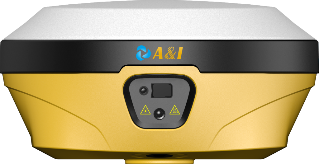
Physical obstructions frequently block direct line-of-sight to the ground during complex urban and industrial construction surveys. Combining micro-electromechanical inertial measurement units with advanced board antennas enables dynamic tilt compensation without manual leveling routines on uneven terrain.
Engineers utilizing specialized hardware engineered by Archimedes Innovation measure offset targets safely in cluttered and hazardous environments. Continuous sensor fusion monitors tilt angles dynamically to prevent positional drift during rigorous measurement sweeps across complex job sites.
Integrated laser geodetic modules further extend operational reach by calculating precise distances to inaccessible surfaces directly without physical contact. Operating a high precision GNSS unit equipped with dual-camera alignment streamlines non-contact spatial data collection significantly across difficult sites.
Industrial form factors balance structural durability with lightweight portability for demanding field technicians operating in extreme climates globally. Ruggedized magnesium housings protect internal processing boards from severe vibrational stress, moisture intrusion, and accidental field drops.
Field Workflow Resilience and Communication Protocols
Network architecture flexibility dictates how smoothly differential correction data travels from base infrastructure to remote field units. Built-in radio transceivers utilizing LoRa communication protocols support long-range data transmission across multi-kilometer zones without cellular coverage dependencies.
Integrated 4G LTE modems maintain robust cloud connectivity for continuous CORS network corrections during extensive municipal utility mapping projects. Dual-battery management systems provide extended operational endurance throughout rigorous twelve-hour surveying shifts in remote geographic regions.
Field crews navigating complex industrial layouts benefit from augmented reality software interfaces embedded within modern controller platforms seamlessly. Visual guidance tools project stakeout points directly onto live camera feeds, accelerating layout verification workflows dramatically for operators in the field.
Technicians deploying technology from Archimedes Innovation eliminate repetitive manual centering errors entirely during critical site layout phases. Comprehensive data logging formats guarantee seamless compatibility with mainstream CAD and GIS processing software suites used across engineering offices.
Quality Assurance and Long-Term Geodetic Reliability
Rigorous quality assurance standards ensure that raw spatial data translates reliably into actionable engineering blueprints and geographic databases. Evaluating system performance involves analyzing baseline repeatability, fix-rate stability, and multipath suppression metrics under adverse field conditions.
Modern geodetic engineering increasingly relies on a high precision GNSS solution to automate heavy machinery guidance and structural health monitoring. Continuous firmware updates adapt tracking algorithms to emerging satellite signal frequencies and civilian navigation constellations to future-proof capital investments.
Precision agriculture, autonomous infrastructure development, and digital construction depend entirely on uninterrupted centimeter-level positioning accuracy. Selecting robust positioning hardware safeguards capital investments against premature obsolescence in rapidly evolving geospatial markets worldwide.
Field validation tests confirm that a deployed RTK receiver maintains sub-centimeter repeatability across extensive baseline networks under variable skies. Systems developed by Archimedes Innovation establish new benchmarks for reliability, operational versatility, and measurement efficiency globally.
